
How drones and modelling can support climate resilience in informal settlements
19 September 2025
![]()
People living in informal settlements face heightened flood risks due to hazardous locations on low-lying lands and riverbanks, inadequate infrastructure like drainage systems, and limited access to services, which compound their vulnerability. Understanding where and how floods develop is therefore essential to design solutions that help communities manage localised flood impacts.
Narrow pathways, uneven terrain, and improvised structures make these environments particularly difficult to assess using traditional flood models. RISE’s environmental research lead, Dr Brandon Winfrey from Monash University’s Department of Civil and Environmental Engineering, is working to understand the underlying factors driving environmental contamination in informal settlements.
Working closely with teams in Fiji, and soon in Indonesia, Winfrey is leading the development of high-resolution flood models using drone imagery, digital elevation data, and climate simulation tools. The goal is to generate more accurate, community-scale flood predictions that can help inform climate adaptation, infrastructure planning, and health-focused interventions.
“Informal settlements are incredibly dynamic and complex,” Winfrey explains. “You can’t rely on coarse, low-resolution data to understand how water moves through these spaces. You miss the detail — and the detail is where the risk lives.”
From the sky to the surface: capturing elevation data
The project began with the creation of digital terrain models (DTMs) and digital elevation models (DEMs) for six RISE settlements in Fiji. These high-resolution maps are built using photogrammetry, a method that converts 2D aerial images into 3D surfaces.
“We need both the natural terrain and what’s visible from above — like buildings or other obstructions — to understand flooding. A lot of post-processing work goes into stitching these models together accurately,” Winfrey says.
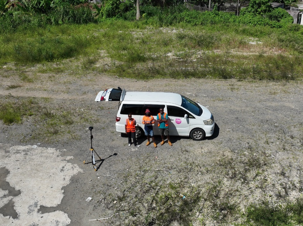
To make this happen, RISE data officers in Suva have been playing a key role. Waisale Rakusa and Maika Nativa supported drone mapping efforts and were trained in drone image processing using Agisoft Metashape Professional — a software that turns drone imagery into useful products like orthomosaics and elevation maps.
Rakusa says, “Through this, I was able to expand my knowledge in remote sensing. I already had experience with drone mapping, but learning the image processing side was a big step forward.”
Nativa, who assisted with drone flights, adds: “I got hands-on experience and now I’m really keen to become a certified drone pilot as well.”
![]()
![]()
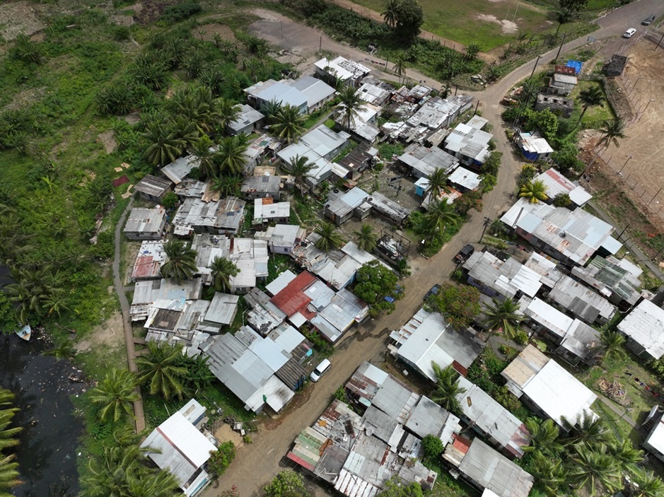
Suva, Fiji: Drone image of an informal settlement. Photo: Waisale Rakusa and Maika Nativa.
![]()
![]()
Modelling floods, validating risk
Once the elevation data is captured and processed, it’s fed into HEC-RAS, a flood modelling software used to simulate how water flows through the settlements.
Using this improved data, the team has started modelling flood scenarios based on design storm events — simulated rainstorms calibrated using satellite-derived rainfall estimates. One early simulation showed flood depths reaching over one metre in parts of a settlement after a moderate six-hour rain event.
The next step is to validate these simulations using on-the-ground observations. Stage two of the project involves flying drones after real flood events to capture the extent of water ponding and compare it to the model outputs. Household flood surveys that RISE conducts with residents will also provide important data points for calibration and validation of the flood models.
“We want to be able to say not just where it floods, but how that flooding might impact health — and how different infrastructure or climate scenarios could affect that risk,” Winfrey says.
Beyond the technical benefits, Rakusa and Nativa say the drone work has also brought a new perspective to the communities themselves participating in RISE.
“Aerial images provide a different and deeper perspective of the settlements — even residents are surprised when they see them,” Nativa says. “Through this, they can prioritise improvements and identify contamination sources or hazards that might not be obvious from the ground.”
![]()
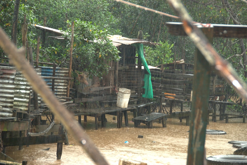 Suva, Fiji: Flooding events underscore the importance of modelling that integrates climate risks with
urban growth and community resilience.
![]()
Looking ahead
The cross-country team now plans to expand the flood modelling work in Indonesia and improve the simulation tools further — refining infiltration rates, testing alternative rainfall scenarios, and enhancing the stitching of elevation data for smoother modelling transitions.
“We’d love to build a working group in RISE to train others on this kind of modelling,” says Winfrey. “It’s complex work, but with the right tools and training, it can have real impact — not just for flood management, but for longer-term planning of solutions to impact community health and resilience.”
![]()
![]()
